Haines Junction Travel Guide: Gateway to Kluane National Park
Haines Junction is a small community with an outsized position — it sits at the edge of Kluane National Park, home to the largest non-polar icefields in the world. This guide covers the town, the park, the cultural centre, and how to make it your base for the southwest Yukon.
Haines Junction — home to roughly 600 people — sits where the Alaska Highway meets the Haines Road (Highway 3), 158 kilometres west of Whitehorse. On clear days you can stand in town and see the St. Elias Mountains stacked to the southwest, peaks over 4,000 metres catching the light. The community grew up around the road, but it lives now as the front door to Kluane National Park and Reserve — a UNESCO World Heritage Site wrapped around the largest non-polar icefields on Earth.
## Getting There
Haines Junction is 158 kilometres west of Whitehorse on the Alaska Highway — about a 90‑minute drive if you’re not stopping every ten minutes for photos. It’s classic open boreal country most of the way, with the Kluane Ranges starting to build on your left as you head west.
From Alaska, Haines Junction is your first proper Yukon stop after crossing from Tok on the Alaska Highway (from Tok: roughly 280 km / about 3 hours in good conditions). From Haines, Alaska, it’s about 250 kilometres north on the Haines Road — a road I’d put up against any in the North. You climb out of coastal rainforest, over Chilkat Pass with tidewater glaciers hanging in the distance, then drop into the drier Yukon Interior.
There’s no commercial airline service into Haines Junction itself. Most people fly into Whitehorse and drive, or come in over the roads from Alaska.
## What to See and Do
*Kluane National Park and Reserve Visitor Centre*
The [Kluane National Park and Reserve Visitor Centre](https://parks.canada.ca/pn-np/yt/kluane) in Haines Junction should be your first stop before you set foot on any trail. Parks Canada staff will give you up‑to‑the‑minute trail conditions, recent bear and wildlife reports, fire bans, and alpine weather that usually looks nothing like what you’re seeing in town. They’ll also steer you toward routes that actually fit your time and fitness, which is something many people misjudge in Kluane’s front ranges.
Inside, the exhibits do a solid job of laying out the park’s geology, ecology, and the ice age story that sculpted all those big valleys and icefields you’re about to drive past.
*Da Ku Cultural Centre*
[Da Ku Cultural Centre](https://dakuculturalcentre.ca/), run by the Champagne and Aishihik First Nations, anchors Haines Junction in something deeper than highways and park maps. The exhibits walk you through thousands of years of CAFN history in the Kluane region — a relationship with this land that predates every road, mine, and border line on your atlas.
The building itself is worth a slow look; its architecture nods to traditional forms without feeling like a museum prop. Inside, you’ll also find the story of the Alaska Highway blasting through CAFN territory in 1942, a project that brought sudden and often unwelcome change to people who were never asked for permission. It’s open in summer, admission by donation, and it adds essential context to everything else you’ll do here.
*Hiking in Kluane*
### The Auriol Trail (15 km loop, 5–6 hours, moderate) leaves from the Alaska Highway about 7 kilometres south of Haines Junction. The path pulls you through spruce and poplar, then up into sub‑alpine meadows where you can look out across the Shakwak Valley. June and July are prime time for bird song and wildflowers. The first half of the loop stays fairly gentle; the ridge section is where you earn and get the bigger views.
### The King’s Throne Trail above Kathleen Lake (trailhead on the Haines Road, 26 km south of Haines Junction) is, in my opinion, the best single‑day hike you can do by road access in Kluane. From the Kathleen Lake Campground, the trail wastes no time — it climbs steeply through forest, then breaks into sub‑alpine slopes and scree, aiming straight for a huge cirque carved into the mountain.
That cirque is your destination. You sit in the “seat,” ringed by throne‑like walls of rock, staring across Kathleen Lake and the front ranges. Distance to the cirque is roughly 5 km one way with about 800 metres of elevation gain. Plan on 5–7 hours return. It’s a strenuous hike on loose rock in places; good footwear isn’t optional, and you should be carrying bear spray and know how to use it.
### The Rock Glacier Trail (about 1.5 km return, easy) near the park visitor centre is a good introduction to Kluane’s geology at a more relaxed tempo. Short, well‑marked, and suitable for most families, it still gives you that feeling of walking on a living, slowly moving landscape.
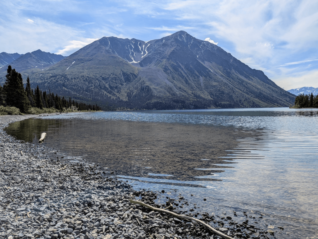
*Kathleen Lake*
Kathleen Lake, 26 kilometres south of Haines Junction on the Haines Road, is the park’s front porch — the most accessible piece of Kluane, and one of the spots I keep coming back to. The water is a clear glacial turquoise, cold enough that even on a hot day you won’t be in long, and the Kluane Ranges rise straight off the southern shore.
On a calm morning you’ll see canoes and packrafts sliding along the shoreline, and the odd hardy soul taking a quick dip. Shore fishing for lake trout is possible from a few accessible spots. The Parks Canada campground here is lakeside and understandably popular; it’s reservable and tends to fill fast in peak season, so book as far ahead as you can.
*Flightseeing*
Several operators based in Haines Junction run glacier flightseeing tours into Kluane. If you’ve ever wanted to see what the world’s largest non‑polar icefield actually looks like, this is how you do it. From the air, the St. Elias Mountains unfold in layers — nunataks poking through the ice, crevassed rivers of glacier, and peaks that seem to stack forever.
There are short 30‑minute overflights and longer trips that land you right on the ice. It’s not a budget outing, but for many visitors this ends up being the story they tell for years afterwards.
*The Haines Road*

Even if you’re not planning to go all the way to Haines, Alaska, it’s worth pointing your vehicle south on the Haines Road (Highway 3) for a few hours. For the first 40 kilometres or so, the highway runs alongside the front ranges of Kluane, with the mountains right there out your window.
From there it climbs toward Chilkat Pass (elevation about 1,065 m). On a clear day, you get Kluane’s ranges to the north and west, the Alsek Range to the east, and big open sky in every direction. Dall sheep are often visible as pale dots on the darker rock above the road — bring binoculars if you’ve got them. Dezadeash Lake, 15 kilometres south of Haines Junction, is a broad, windswept lake with a territorial campground tucked into the trees along the shore.
## Where to Stay
The [Raven Hotel](https://www.travelyukon.com/en/see-and-do/experience-providers/ravens-rest-inn) is the pick of the bunch in town — a small, comfortable place with a restaurant locals actually eat at, which tells you most of what you need to know. The Cozy Corner Motel and the Fas Gas/Stardust Motel offer simpler, more utilitarian rooms at lower prices if you’re mostly here to hike and just need a bed.
A handful of smaller spots — including the Alkan Air B&B and a few lodges and guest houses around the junction — round out the options. In summer, book ahead if you’re picky about where you sleep; Haines Junction is small, and busy weekends can fill it.
Kathleen Lake Campground (Parks Canada, reservable through reservation.pc.gc.ca) is, for my money, the best camping in the area: sites tucked in the trees with the Kluane Ranges rising straight across the water. It books fast in prime season, so get on it early. When Kathleen is full, Pine Lake Territorial Campground, 7 kilometres east of Haines Junction on the Alaska Highway, makes a good backup with easier access to town.
## Where to Eat
The Raven Hotel restaurant is your go‑to for a proper sit‑down supper — reliable food, a decent beer and wine list, and the kind of hearty plates that make sense after you’ve been pushed around by mountain weather all day. It’s the only true full‑service dining option in town.
For mornings and midday, the [Village Bakery](https://www.villagebakeryyukon.com/) is the place you’ll keep finding excuses to revisit. Strong coffee, good breakfasts and lunches, and baked goods that have derailed more than one hiking plan — the cinnamon buns are a justifiable detour all on their own. The gas station on the highway handles the basics: coffee, sandwiches, and other grab‑and‑go fuel.
If you’re planning to cook for yourself, stock up on groceries in Whitehorse. Haines Junction has a very limited selection, fine for topping up, not for outfitting a week‑long trip.
## Best Time to Visit
Late June through August is prime time for hiking and general park access. Most of the alpine trails shake off their snow by late June, and the high‑country wildflowers are usually at their peak in July. Kathleen Lake Campground typically opens in late May and closes in mid‑September, but always check current dates.
September is hard to beat if you don’t mind scraping frost off the windshield in the morning. The boreal forest below the park goes yellow and orange, and the larch (tamarack) on the alpine slopes turn a deep gold. Bear activity ramps up in the fall as they feed hard before winter, so keep your head up and your bear practices sharp.
Through winter and the shoulder seasons, the Haines Road can close or see travel advisories when weather turns ugly. If you’re travelling October through April, check Yukon 511 for current road conditions before you set off.
## Practical Tips
Fill your tank in Haines Junction before you head south on the Haines Road. There are no guaranteed services for the full 250 kilometres to Haines, Alaska. Fuel is sometimes available closer to the border in the Dalton Post area, but you shouldn’t rely on it — treat Haines Junction as your last sure stop.
If you’re hiking anywhere in Kluane beyond a roadside stroll, carry bear spray and know how to use it. Grizzly bears are common in the park and along the front ranges. You can rent bear spray in Haines Junction if you’d rather not fly with it.
The Alsek River runs through the remote southern end of Kluane and then threads its way to the Pacific through Glacier Bay. It’s a world‑class, big‑water wilderness rafting trip — one of the most demanding, and most spectacular, river journeys in North America. You’ll need a permit (numbers are limited and competition is stiff) and serious expedition experience. Tatshenshini Expediting, based in Haines Junction, is the main logistics hub for Alsek trips.
---
## See Also on TheKlondike.net
- [The Champagne and Aishihik First Nations: Guardians of the Southwest](/blog/champagne-aishihik-first-nations-history) — the First Nation who co‑manage Kluane National Park
- [The Kluane First Nation: People of the Lake and the Mountains](/blog/kluane-first-nation) — whose territory encompasses Kluane Lake
- [Kluane National Park: Where the Mountains Begin](/blog/kluane-national-park-guide) — what’s inside the park boundaries
- [Whitehorse Travel Guide](/blog/whitehorse-essential-guide) — 158 km east, the starting point for most visitors
- [Burwash Landing Travel Guide](/blog/burwash-landing-kluane-museum) — on the shores of Kluane Lake, 100 km northwest