Carmacks Travel Guide: Midpoint on the Klondike Highway
Carmacks sits at the halfway point of the Klondike Highway, on the banks of the Yukon River. Its Five Finger Rapids were once the most feared obstacle on the gold rush river route. Today the community is a practical stop with a beautiful campground and an important cultural heritage.
Carmacks sits at kilometre 355 of the Klondike Highway — the midpoint between Whitehorse and Dawson City — on the banks of the Yukon River. The community of about 500 people is named for George Carmack, one of the three men credited with the 1896 gold discovery on Bonanza Creek. Before that discovery made him famous, Carmack operated a trading post and coal mine at this river crossing. The Little Salmon/Carmacks First Nation have lived along this stretch of the Yukon River for thousands of years; the community today reflects both that deep history and the highway economy that has dominated since the 1950s.
## Getting There
Carmacks is 355 kilometres north of Whitehorse on the Klondike Highway and 355 kilometres south of Dawson City — a geographic symmetry that makes it the natural fuel and rest stop for drivers making the full run. From Whitehorse, allow 3.5 to 4 hours. The road is paved throughout; the section north of Carmacks toward Dawson is in generally good condition but has occasional rough patches and frost heaves. There is no airport; the community is road-accessible only.
## Five Finger Rapids
The Five Finger Rapids, 25 kilometres north of Carmacks, were the most feared obstacle on the gold rush stampeders' river route from Whitehorse to Dawson City. The Yukon River narrows here and is divided by four basalt rock columns into five channels. Gold rush vessels required ropes (lining) or hired local pilots to navigate the rightmost channel — the only passage deep enough for fully loaded boats. Many vessels were damaged or lost here; the police eventually stationed observers to monitor the crossing.
Today, a Parks Canada viewing platform reached by a short trail (about 800 metres return) from a signed highway pullout gives an excellent view of the rapids and the basalt columns. The rapids are still impressive — the river compresses visibly through the channels, and the geology (ancient lava flows) is dramatic. Interpretive signs explain the gold rush history. Do not miss this stop; it's one of the most evocative spots on the full Klondike Highway.
## What to See and Do
*Tage Cho Hudän Interpretive Centre*
The Little Salmon/Carmacks First Nation's [Tage Cho Hudän Interpretive Centre](https://www.heritageyukon.ca/our-heritage/heritage-places/tage-cho-hudan-interpretive-centre/) covers the deep history and culture of the people of the middle Yukon River — the pre-contact territory, the traditional seasonal round, the arrival of the trading post economy, and the path to self-government. The centre is in the community; open seasonally in summer.
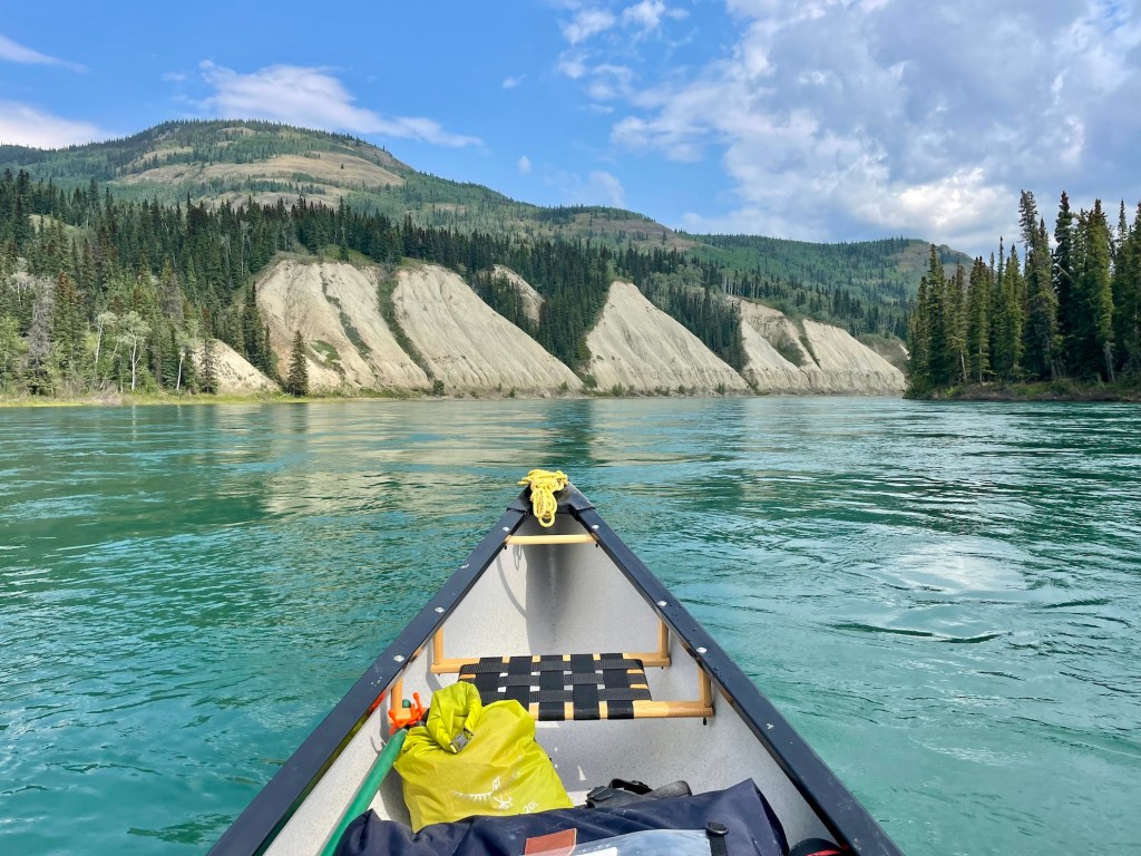
*The Yukon River*
The Yukon River at Carmacks is wide, grey-green, and powerful. It is paddled regularly — the stretch from Carmacks to Dawson City (approximately 355 km) takes paddlers six to ten days and is one of the great canoe routes in Canada. The route passes through Five Finger Rapids (manageable for experienced paddlers but requiring scouting), Rink Rapids, and long stretches of wilderness river. Canoe rentals and shuttle services are available; ask at the Carmacks Hotel or the visitor information centre.
The Yukon River Quest, an annual canoe and kayak race from Whitehorse to Dawson City, passes through Carmacks each year in late June. Watching the competitors arrive at the Carmacks checkpoint — most have been paddling continuously for 24+ hours by this point — is a genuine spectacle.
*Coal Mine Lake*
Coal Mine Lake, on the edge of Carmacks, is stocked with rainbow trout and accessible from the community. The lake is named for the coal mine George Carmack operated here in the 1890s — the coal seams in the surrounding hillsides are still visible. A pleasant spot for an afternoon of fishing with relatively easy access.

*The Freegold Road*
For those with a higher-clearance vehicle and a spirit of exploration, the Freegold Road heads northwest from Carmacks into the Dawson Range — a remote area of old placer mining claims and boreal wilderness. The road is unpaved and conditions vary; confirm current status locally before attempting. The scenery is excellent and the road is rarely travelled.
## Outdoor Adventures
### Hiking and Wildlife Viewing
Carmacks offers more than just river views. The surrounding terrain provides excellent opportunities for hiking and wildlife viewing. Trails wind through the boreal forest, offering a chance to spot local wildlife such as moose, caribou, and foxes. Binoculars are recommended for birdwatching, with eagles and various waterfowl frequently seen along the riverbanks and in the forests.
### Winter Activities
While summer is the peak season, winter in Carmacks opens up a different set of adventures. The region experiences long, cold winters with plenty of snow, ideal for snowshoeing and cross-country skiing. Trails are less defined but offer serene landscapes blanketed in snow. Local knowledge is crucial for safe navigation, as marked trails are limited. The Northern Lights often illuminate the winter night sky, providing a stunning natural light show for those willing to brave the cold.
## Where to Stay
The Carmacks Hotel is the main accommodation option — rooms are functional, the restaurant is the primary dining in town, and the staff can point you toward local information. The Coal Mine Campground on the Yukon River, a kilometre or so south of town, is one of the best government campgrounds on the Klondike Highway: large, well-maintained sites in a spruce forest with river views. It fills by early afternoon in peak season — arrive by 2pm to be safe. First-come, first-served.
## Where to Eat
The Carmacks Hotel restaurant is the primary dining option — standard Canadian road food done reliably, with breakfast available early for those continuing north. The gas station on the highway has a small deli counter and grab-and-go items. Bring food from Whitehorse if you have dietary requirements beyond the basics.
## Best Time to Visit
June through August for full access and comfortable conditions. The Yukon River Quest passes through in late June. Fall (September) brings excellent colours to the boreal forest and quieter roads. The highway is plowed and maintained year-round, though winter driving north of Carmacks requires experience.
## Practical Tips
Fuel is available in Carmacks — fill up here. The next reliable fuel north is Pelly Crossing (185 km); south is Whitehorse (355 km) or the small service station at Stewart Crossing (63 km, limited hours). On a highway where service stations can be 180 kilometres apart, Carmacks fuel is not optional.
Cell service is available in Carmacks but becomes unreliable north of town. Download offline maps for the stretch between Carmacks and Dawson City before leaving the community.
The Klondike Highway north of Carmacks passes through some of the most remote and beautiful terrain in the Yukon — the Tatchun Hills, the broad Yukon River valley, the Pelly River crossing at Pelly Crossing. Allow time for stops and wildlife watching; moose, eagles, and black bears are common along this stretch.
---
## See Also on TheKlondike.net
- [The Little Salmon/Carmacks First Nation: People of the Midpoint](/blog/little-salmon-carmacks-first-nation) — the First Nation whose traditional territory this is
- [Dawson City Travel Guide](/blog/dawson-city-48-hours) — 355 km north, the end of the Klondike Highway
- [Whitehorse Travel Guide](/blog/whitehorse-essential-guide) — 355 km south, the starting point
- [The Klondike Highway: Skagway to Dawson City](/blog/klondike-highway-skagway-to-dawson) — the full highway route
## Local Culture and Events
### Community Gatherings
Carmacks is a small community with a rich cultural tapestry. Throughout the year, various local events and gatherings offer a glimpse into the life and traditions of its residents. The Little Salmon/Carmacks First Nation hosts events that celebrate their heritage, including traditional drumming, dancing, and storytelling sessions. These gatherings provide an excellent opportunity for visitors to engage with the local culture and learn about the area’s history from those who know it best.
### Seasonal Celebrations
While the summer months are popular for travel, visiting during a seasonal celebration can offer a unique experience. Events such as the annual Carmacks Music Festival bring the community together with live performances, food stalls, and artisan crafts. These events are typically family-friendly and showcase local talent and craftsmanship. Information on upcoming events can be obtained from the Carmacks Visitor Information Centre or community bulletin boards.
## Exploring Beyond Carmacks
### Mount Nansen
For those looking to explore the greater area, a trip to Mount Nansen offers a scenic adventure. Located approximately 60 kilometres west of Carmacks, Mount Nansen is accessible via a combination of paved and gravel roads. The area boasts expansive views and opportunities for hiking, particularly appealing for those interested in geology and mining history. The remnants of old mining activity can still be seen, providing a tangible connection to the region's past economic drivers.
### Tatshenshini-Alsek Park
While slightly further afield, Tatshenshini-Alsek Park, a UNESCO World Heritage Site, is worth a visit for those with more time. The park is renowned for its breathtaking landscapes, including glaciers, rivers, and diverse wildlife. Though primarily accessed from the Haines Junction area, its proximity to Carmacks makes it a viable addition for adventurous travelers seeking to extend their Yukon explorations.
## Practical Tips for Remote Travel
### Vehicle Preparation
Given the remote nature of the area, ensuring your vehicle is well-prepared is essential. Carry a spare tire, extra fuel, and basic tools. Cell service is limited, so a satellite phone or GPS device can be invaluable for emergencies. Always inform someone of your travel plans if venturing into less-traveled areas.
### Wildlife Safety
Wildlife is abundant in the Yukon, and travelers should be prepared for encounters. Carry bear spray and know how to use it. Store food securely and adhere to guidelines for wildlife interactions. Respecting the natural habitat ensures both your safety and the preservation of the ecosystem.